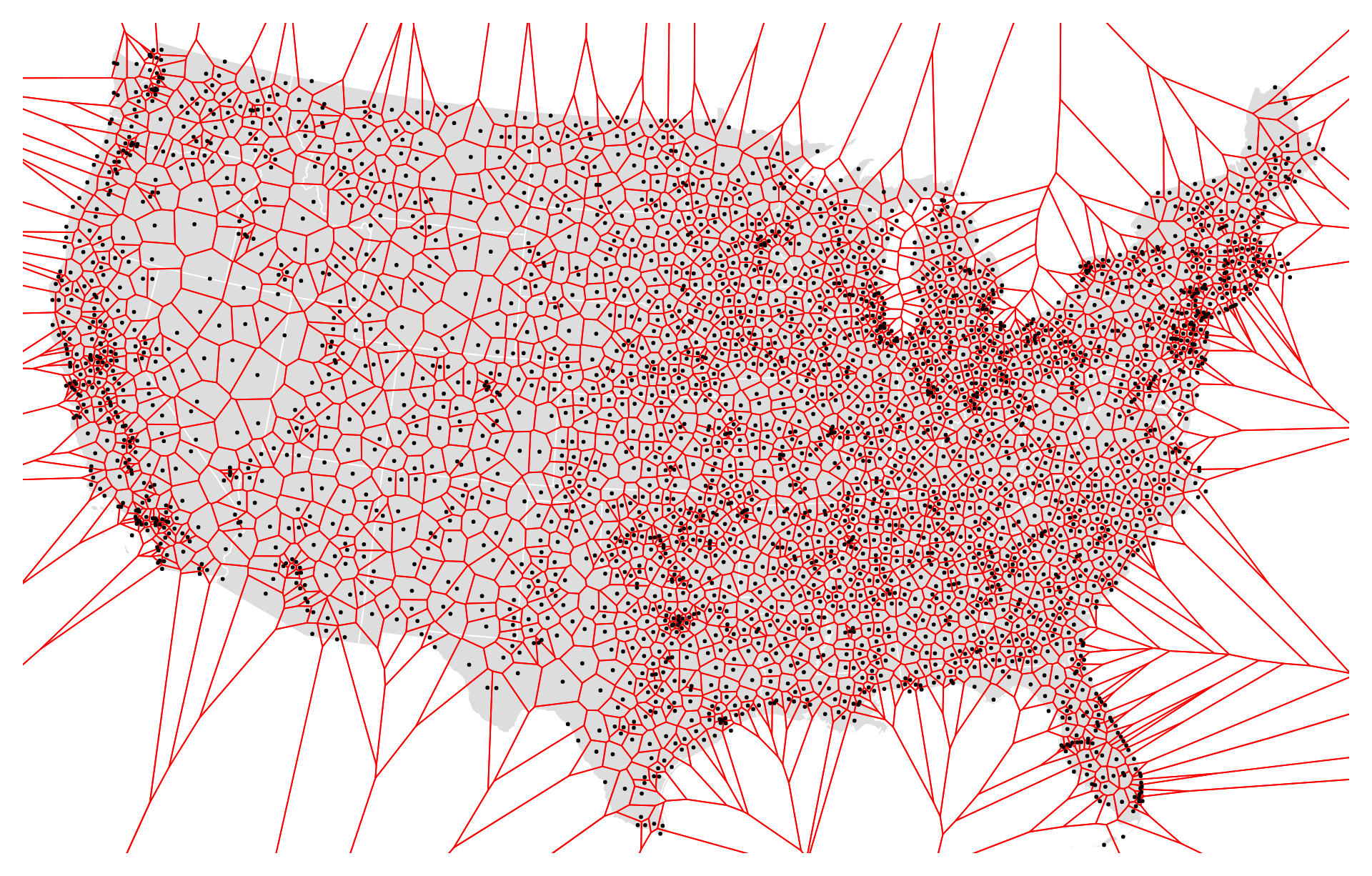
The US airport Voronoi diagram is a spatial representation that divides the United States into regions based on the closest airport to any given point. Named after mathematician Georgy Voronoi, these diagrams partition space into cells, where each cell contains all the points closer to a particular airport than to any other airport. This diagram helps in visualizing the coverage area and proximity of airports across the country, assisting in air traffic management, route planning, and understanding regional air transportation infrastructure.
Purpose :
Airspace Partitioning: Voronoi diagrams can be used to partition the airspace around airports into distinct regions known as Voronoi cells or Voronoi polygons. Each Voronoi cell represents the airspace that is closest to a specific airport compared to any other airport in the region. This partitioning helps in defining the responsibility areas of different airports in managing air traffic within their vicinity.
Air Traffic Management: By delineating the Voronoi cells around airports, air traffic controllers can efficiently manage incoming and outgoing flights within their respective areas. This aids in coordinating aircraft movements, assigning arrival and departure routes, and ensuring safe spacing between aircraft, thereby minimizing the risk of mid-air collisions and optimizing airspace utilization.
Navigation and Routing: Pilots and air traffic controllers use Voronoi diagrams to determine the closest airport to a given location in case of emergencies or diversions. Knowing which airport’s airspace covers a particular area helps in selecting diversion routes and providing guidance to aircraft during unexpected situations such as adverse weather conditions or mechanical failures.
Airport Planning and Expansion: Voronoi diagrams assist airport authorities and planners in assessing the coverage and influence of existing airports and identifying areas that may benefit from the construction of new airports or expansion of existing facilities. By analyzing Voronoi cells, decision-makers can prioritize infrastructure investments, allocate resources efficiently, and enhance the overall aviation infrastructure.
Emergency Response and Search and Rescue: In emergency situations such as aircraft accidents or distress calls, Voronoi diagrams provide valuable information for coordinating search and rescue operations. Emergency responders can quickly determine which airport has jurisdiction over the incident location and initiate rescue efforts accordingly, expediting response times and potentially saving lives.
Uses :
The use of Voronoi diagrams in the context of US airports, also known as airport Voronoi diagrams, serves several practical purposes in aviation and airspace management. Here are some key uses:
Air Traffic Control (ATC):
Airspace Partitioning: Airport Voronoi diagrams help in dividing the airspace around airports into regions, with each region corresponding to the area closest to a specific airport. This partitioning aids air traffic controllers in efficiently managing arriving and departing flights within their respective sectors.
Sectorization: Voronoi diagrams assist in sectorizing ATC airspace, allowing controllers to allocate resources effectively and ensure safe separation between aircraft. Each Voronoi cell defines the responsibility area of a particular airport’s ATC facility, facilitating coordination and communication between controllers.
Flight Planning and Navigation:
Route Planning: Pilots and flight planners use airport Voronoi diagrams to determine the closest suitable airport for diversion or emergency landing in case of unforeseen circumstances such as weather deviations, mechanical issues, or medical emergencies.
Navigation Aid: Voronoi diagrams serve as a navigational aid for pilots, providing a visual representation of airports and their coverage areas. Pilots can reference Voronoi cells to identify nearby airports and plan flight routes accordingly.
Airport Planning and Development:
Infrastructure Expansion: Airport Voronoi diagrams assist airport authorities and planners in evaluating the coverage and service areas of existing airports. This information guides decisions regarding airport expansion, infrastructure development, and facility upgrades to meet growing aviation demand.
Strategic Planning: By analyzing Voronoi diagrams, stakeholders can identify underserved regions or areas with inadequate airport access. This insight informs strategic planning efforts aimed at improving air transportation accessibility and enhancing regional connectivity.
Emergency Response and Search and Rescue:
Incident Management: During aviation emergencies, such as aircraft accidents or medical evacuations, airport Voronoi diagrams help emergency responders quickly identify the nearest airport with appropriate facilities and resources. This expedites response efforts and ensures timely assistance to those in distress.
Search and Rescue Operations: Voronoi diagrams aid search and rescue teams in determining the jurisdiction of nearby airports and coordinating search efforts effectively. This information assists in locating and rescuing survivors in remote or inaccessible areas.
Aviation Safety and Efficiency:
Reducing Congestion: By delineating airspace coverage areas, Voronoi diagrams help distribute air traffic evenly among airports, thereby reducing congestion and delays in high-traffic regions.
Enhancing Safety: Airport Voronoi diagrams contribute to aviation safety by facilitating efficient airspace management, minimizing conflicts between aircraft, and optimizing traffic flow around airports.
Overall, airport Voronoi diagrams play a crucial role in airspace management, flight operations, airport planning, emergency response, and aviation safety, contributing to the efficient and safe operation of the US airspace system.
Reviews
There are no reviews yet.
Only logged in customers who have purchased this product may leave a review.


Reviews
There are no reviews yet.