Description
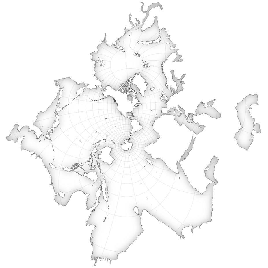
The Spilhaus shoreline map, also known as the Spilhaus projection, is a unique cartographic representation that centers on Earth’s oceans, with land masses encircling the edges. Developed by Athelstan Spilhaus, a South African oceanographer, this projection prioritizes the depiction of oceanic features, such as currents and bathymetry, while still including simplified representations of continents and major geographic features. Its polar orientation provides a distinct perspective on global oceanic circulation patterns, making it valuable for oceanography, marine science, and educational purposes.
The Spilhaus shoreline map serves several purposes, including:
- Oceanographic Studies: The map is designed to provide a detailed visualization of Earth’s oceans, making it valuable for oceanographic research. It allows scientists to study ocean currents, bathymetry, and other oceanographic features in detail.
- Understanding Oceanic Circulation: With its focus on oceanic features and polar orientation, the Spilhaus shoreline map offers insights into global oceanic circulation patterns. Researchers can use it to better understand the complex dynamics of ocean currents and their role in Earth’s climate system.
- Marine Biology and Ecology: The map can be used by marine biologists and ecologists to study the distribution of marine species, habitats, and ecosystems. It provides a comprehensive view of oceanic environments, helping researchers identify areas of ecological importance.
- Environmental Studies: Environmental scientists and policymakers may use the map to assess the impact of human activities on the world’s oceans, such as pollution, overfishing, and climate change. It provides a visual representation of oceanic ecosystems and their vulnerabilities.
- Educational Purposes: The Spilhaus shoreline map is often used in educational settings to teach students about oceanography, geography, and Earth sciences. Its unique perspective on the world’s oceans can help students gain a deeper understanding of Earth’s interconnected systems.
- Navigation and Exploration: While not typically used for navigation, the map can aid in visualizing oceanic routes and exploration paths. It may be used by navigators, explorers, and researchers planning oceanic expeditions or scientific missions.
- Climate Studies: Climate scientists may use the map to study the role of the oceans in regulating Earth’s climate. It provides a visual representation of ocean-atmosphere interactions, helping researchers analyze climate variability and change.
- Comparative Analysis: The Spilhaus shoreline map can be compared with other map projections to highlight differences in how oceanic features are represented. This comparative analysis can provide insights into the strengths and limitations of different mapping techniques.
Uses :
The Spilhaus shoreline map, with its unique focus on Earth’s oceans and polar orientation, finds various uses across different fields. Some common uses include:
- Oceanography: The map serves as a valuable tool for oceanographers studying ocean currents, bathymetry, and other oceanic features. Its emphasis on the oceans provides insights into global circulation patterns and oceanic processes.
- Climate Science: Climate scientists use the Spilhaus shoreline map to study the role of oceans in Earth’s climate system. It helps visualize ocean-atmosphere interactions, climate variability, and the impacts of climate change on oceanic circulation.
- Marine Biology: Marine biologists use the map to study marine habitats, species distributions, and ecosystems. Its ocean-centric perspective aids in understanding the spatial relationships between different marine environments and species.
- Environmental Monitoring: The map is used for monitoring and assessing environmental conditions in the world’s oceans. It helps track changes in ocean temperature, salinity, and sea ice extent, as well as the distribution of pollutants and marine debris.
- Education: The Spilhaus shoreline map is used in educational settings to teach students about oceanography, geography, and Earth sciences. Its unique perspective on the oceans enhances students’ understanding of Earth’s interconnected systems.
- Navigation: While not typically used for navigation, the map may aid in visualizing oceanic routes and exploration paths for navigators and researchers planning oceanic expeditions or scientific missions.
- Policy and Planning: Policymakers and planners use the map to inform decision-making related to ocean conservation, resource management, and maritime spatial planning. It provides a comprehensive view of oceanic environments and their vulnerabilities.
- Research and Exploration: Researchers and explorers use the map to plan and conduct scientific expeditions, oceanographic research, and exploration missions. Its visualization of oceanic features helps identify areas of interest and plan research activities.
- Comparative Analysis: The Spilhaus shoreline map can be compared with other map projections to analyze differences in how oceanic features are represented. This comparative analysis provides insights into the strengths and limitations of different mapping techniques.
Only logged in customers who have purchased this product may leave a review.
Related products
-
- Sale!
Hexbin
-
$ 15Original price was: $ 15.$ 10Current price is: $ 10. - Add to cart
-
- Sale!
Volcano Contours
-
$ 15Original price was: $ 15.$ 10Current price is: $ 10. - Add to cart
-
- Sale!
Density Contours Charts
-
$ 15Original price was: $ 15.$ 10Current price is: $ 10. - Add to cart

Reviews
There are no reviews yet.